使用 SENTINEL 1 和 2 进行土地覆盖分类

1.前言
Sentinel-1 和 Sentinel-2 卫星都以非常高的空间分辨率和良好的时间分辨率对地球进行测量。 这些数据对于绘制土地利用和土地利用变化图非常有用。 本教程展示了如何使用简单的算法来识别水、茂密植被、定居点和稻田的区域。
2.代码实现
(1)导入 Sentinel-1 和 Sentinel-2 ImageCollection

(2)定义地理和时间域
// Define period
var startdate = ee.Date.fromYMD(2014,1,1);
var enddate = ee.Date.fromYMD(2016,12,1);// Define geograpic domain
var Ca = ee.FeatureCollection('ft:1T7GmJ0tJCu4QwclY5qiG9EGBFgNhhNjttq8F7gQm');
Map.centerObject(Ca,8);
(3) 过滤数据
// filter s2 data</pre>
var Sentinel2 = s2.filterBounds(Ca)
.filterDate(startdate, enddate)
.filterBounds(Ca);// filter s1 data
var Sentinel1 =  ee.ImageCollection('COPERNICUS/S1_GRD')
.filterBounds(Ca)
.filterDate(startdate, enddate)
.filter(ee.Filter.listContains('transmitterReceiverPolarisation', 'VV'))
.select('VV');
(4) 从 Sentinel-2 移除云层
// cloud function to remove clouds
var cloudfunction_ST2 = function(image){//use add the cloud likelihood band to the imagevar quality = image.select("QA60").unmask();//get pixels above the thresholdvar cloud01 = quality.gt(0);//create a mask from high likelihood pixelsvar cloudmask = image.mask().and(cloud01.not());//mask those pixels from the imagereturn image.updateMask(cloudmask);
};// remove the clouds
var ST2_nocloud = Sentinel2.map(cloudfunction_ST2);
(5) 从 Sentinel-2 的中值计算 NDBI、NDVI 和 NDWI
// take the median
var st2median = ST2_nocloud.median();// the normalized difference bare index
var ndbi = st2median.normalizedDifference(['B12', 'B8']);// the normalized difference vegetation index
var ndvi = st2median.normalizedDifference(['B8', 'B4']);// the normalize difference water index
var ndwi = st2median.normalizedDifference(['B3', 'B8']);(6)设置索引的阈值
// define thresholds
var bareThreshold = -0.32
var vegetationThreshold = 0.65
var waterThreshold = 0.2
(7)将不同的图层添加到画布
// show the urban area
var ndbi_th = ndbi.gt(bareThreshold)
var myndbi = ndbi_th.updateMask(ndbi_th).clip(Ca)
var ndbi_viz = {palette:"111101"};
Map.addLayer(myndbi, ndbi_viz, 'Urban');// show the water areas
var ndwi_th = ndwi.gt(waterThreshold)
var myndwi = ndwi_th.updateMask(ndwi_th).clip(Ca)
var ndwi_viz = {palette:"24069b"};
Map.addLayer(myndwi, ndwi_viz, 'Water');// show the forests
var ndvi_th = ndvi.gt(vegetationThreshold)
var myndvi = ndvi_th.updateMask(ndvi_th).clip(Ca)
var ndvi_viz = {palette:"006b0c"};
Map.addLayer(myndvi, ndvi_viz, 'Vegetation');
(8)在 sentinel-1 图像上使用 reducer 函数比较干湿条件
// create a map of the wet and dry conditions from sentinel-1
var wet = Sentinel1.reduce(ee.Reducer.percentile([10]))
var dry = Sentinel1.reduce(ee.Reducer.percentile([90]))
(9) 识别在雨季被淹没而在旱季干燥的稻田
// calculate the difference between wet and dry conditions
var paddies = wet.subtract(dry)
(10) 山可以被识别为稻田,所以我们去除所有大于 2 度的坡度
// remove the mountains from the data
var hydrosheds = ee.Image('WWF/HydroSHEDS/03VFDEM');
var terrain = ee.Algorithms.Terrain(hydrosheds);
var slope = terrain.select('slope');// remove all slopes greater then 2 degrees
paddies = paddies.updateMask(slope.lt(2));
(11) 还根据 -8 的阈值将稻田添加到地图中
// set the paddy threshold
var paddies_th = -8;// select areas smaller than the threshold
var paddies_th = paddies.lt(paddies_th);// mask the areas that are not rice paddies
var mypaddies = paddies_th.updateMask(paddies_th).clip(Ca)var paddies_viz = {palette:"c2c64d"};
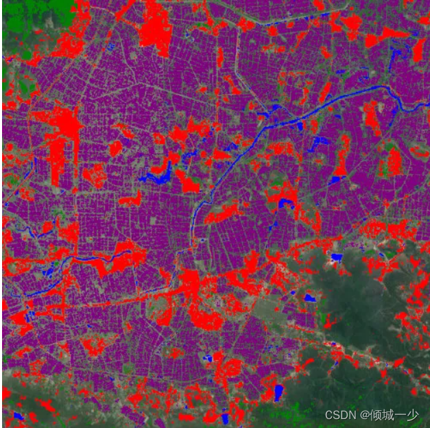
Map.addLayer(mypaddies, paddies_viz, 'Rice');3.实现效果